
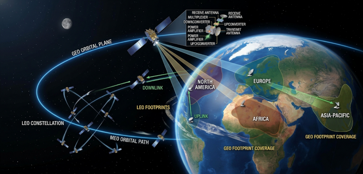
Satellite communication systems carry voice, data and broadcast traffic across distances that terrestrial infrastructure cannot reach economically. Engineers responsible for designing, operating or upgrading these systems need a working command of three interdependent variables: orbit selection, transponder behaviour and footprint coverage. Each variable changes signal reliability, coverage area and operating cost. Understanding how they interact is the difference between a network that performs under pressure and one that fails during the first heavy rainfall event.
This explanation builds on foundational concepts covered in structured learning environments. Teams starting from a general understanding of RF systems benefit from a step-by-step grounding before tackling orbit mechanics and link engineering, which is why many organisations begin with the Satellite Communication Systems and Ground Stations Training Courses, which introduce ground segment architecture, orbital classifications and basic signal flow before advancing into design-level detail.
What Determines the Orbit Selection for a Satellite Communication System?
Orbit selection depends on coverage requirements, latency tolerance and satellite lifespan, with geostationary orbit chosen for fixed coverage and continuous service, while low and medium orbits suit latency-sensitive or polar applications. Three orbital classes dominate commercial and government satellite communication: geostationary orbit (GEO), medium Earth orbit (MEO) and low Earth orbit (LEO).
Geostationary orbit sits at approximately 35,786 kilometres above the equator. A satellite placed here matches Earth's rotational period, appearing fixed relative to a ground observer. This fixed position eliminates the need for continuous ground antenna repositioning, which reduces operating complexity for broadcast, VSAT and backhaul networks. The trade-off is signal latency. A round trip to a geostationary satellite and back introduces approximately 480 to 600 milliseconds of delay, a figure that matters for voice calls and real-time data exchange but has limited impact on broadcast television or one-way data distribution.
Medium Earth orbit, positioned between 2,000 and 35,786 kilometres, is used primarily for navigation constellations such as GPS and Galileo. Latency drops to 60 to 140 milliseconds, and multiple satellites are required to maintain continuous coverage over a given region, since no single MEO satellite remains fixed relative to the ground.
Low Earth orbit, below 2,000 kilometres, delivers latency under 50 milliseconds and supports the broadband constellations now expanding commercial connectivity into remote and maritime regions. LEO systems require constellations of dozens to thousands of satellites to maintain coverage continuity, since individual satellites pass overhead in minutes rather than remaining stationary. Orbit choice, therefore, is not a single technical decision. It is a coverage-versus-latency-versus-cost calculation that shapes every downstream design choice, including transponder allocation and ground segment architecture.
How Do Transponders Process and Relay Signals Across a Satellite Footprint?
A transponder receives an uplinked signal, shifts its frequency, amplifies it and retransmits it as a downlink, with each transponder handling a defined frequency band and bandwidth allocation across the satellite's coverage area. Transponders are the functional core of any communication satellite. Each unit performs three sequential operations on incoming signals.
First, the transponder receives the uplink signal from a ground station, typically in the C-band (4–8 GHz), Ku-band (12–18 GHz) or Ka-band (26–40 GHz), depending on the satellite's design and licensing. Second, it converts the frequency to prevent interference between the incoming uplink and the outgoing downlink, since transmitting and receiving on the same frequency simultaneously would cause self-interference. Third, it amplifies the signal, typically using a travelling wave tube amplifier or solid-state power amplifier, before retransmitting it to Earth as the downlink.
A single satellite carries multiple transponders, often between 24 and 48 on a standard GEO communications satellite, though high-throughput satellites now exceed 100. Bandwidth per transponder typically ranges from 36 MHz to 72 MHz. This allocation determines how many simultaneous channels, data streams or VSAT terminal connections a single transponder can support. Network planners size transponder capacity against expected traffic volume, factoring in modulation scheme and forward error correction overhead, since both affect the usable data rate within a fixed bandwidth allocation.
Transponder health also degrades over a satellite's operational life, generally 15 years for GEO platforms. Amplifier output declines gradually due to component ageing and thermal cycling, which network operators account for by building margin into initial link budget calculations rather than assuming constant performance across the mission lifetime.
What Is a Link Budget and Why Does It Define Signal Reliability?
A link budget is a calculation of all gains and losses between transmitter and receiver, used to confirm that a satellite signal arrives with sufficient strength above the noise floor for reliable demodulation under expected atmospheric conditions. Every satellite communication link, whether broadcast, VSAT or backhaul, depends on this calculation holding in practice, not only on paper.
The link budget accounts for transmitter power, antenna gain at both ends, free-space path loss, atmospheric attenuation, and receiver sensitivity. Free-space path loss alone can exceed 200 dB for a geostationary link, which the combined gain of transmit power and antenna directivity must overcome. Atmospheric attenuation adds further loss, and this is where rain fade becomes the dominant variable for Ku-band and Ka-band systems. Rainfall absorbs and scatters higher-frequency signals significantly more than C-band, meaning a link engineered without adequate fade margin drops below the required carrier-to-noise ratio during moderate to heavy rainfall, causing outages precisely when demand for connectivity often increases.
VSAT terminals, the small-aperture ground antennas used for enterprise, retail and remote-site connectivity, are particularly sensitive to link margin decisions. A VSAT network engineered with insufficient uplink power control or inadequate fade margin experiences service degradation correlated directly with regional weather patterns, a pattern that shows up in service level agreement breaches and customer complaints rather than in the original design documentation. Satellite tracking systems, used for both GEO station-keeping verification and LEO/MEO antenna pointing, add a further layer of precision requirement, since even small pointing errors reduce effective antenna gain and compound the margin problem.
Engineering teams responsible for link budget accuracy under real atmospheric stress, rather than idealised clear-sky conditions, require a level of technical depth that moves beyond conceptual understanding into applied calculation and fade mitigation strategy. This is the specific gap addressed in Engineer Satellite Communication Systems That Survive Rain Fade and Link Margin Pressure, which works through fade margin calculation, adaptive coding and modulation, and uplink power control as applied design decisions rather than theoretical concepts.
How Does Footprint Coverage Affect Network Design and Business Applications?
Footprint coverage is the geographic area on Earth that receives usable signal strength from a satellite antenna beam, and it determines how many ground terminals a single satellite can serve at a commercially viable signal quality. Coverage design is not a fixed outcome of orbital position alone. It results from antenna beam shaping decisions made during satellite manufacturing and configuration.
Global beams cover roughly one-third of the Earth's surface visible from a single geostationary position, delivering broad but low-intensity signal strength suited to applications tolerant of lower carrier-to-noise ratios. Regional beams concentrate power over a defined continent or country, increasing effective isotropic radiated power (EIRP) within that footprint and enabling smaller receive antennas. Spot beams narrow further, focusing high power density onto a specific metropolitan or economic zone, a design increasingly used in high-throughput satellite systems to support dense VSAT deployments and enterprise data services.
For organisations planning connectivity infrastructure, footprint decisions carry direct commercial consequences. A regional bank deploying VSAT terminals across rural branches needs footprint strength calculated against each branch's specific location, not an assumed average across the country. A maritime operator crossing between spot beam boundaries needs a network design that manages beam handover without service interruption. A broadcaster licensing a transponder needs footprint boundaries that match its target advertising market precisely, since coverage that extends beyond the licensed territory creates regulatory exposure without commercial benefit.
These decisions connect directly to workforce capability. Organisations expanding satellite-dependent operations report measurable skill gaps in RF engineering, network planning and satellite systems integration, gaps that widen as high-throughput and multi-orbit constellations become standard infrastructure rather than specialist deployments. Closing this gap through structured training reduces project delays linked to design rework, a cost that frequently exceeds the original training investment once fade-related outages, coverage disputes or transponder mis-sizing are factored into project budgets.
What Skills Do Engineering Teams Need to Manage These Systems Effectively?
Engineering teams need combined competency in RF fundamentals, orbital mechanics, network planning software and applied link budget calculation, since satellite communication design decisions cannot be separated from the programming and data systems that model and monitor them. Modern satellite network planning relies heavily on software tools for coverage simulation, link budget modelling and real-time performance monitoring, which means RF and orbital knowledge alone is no longer sufficient for a fully capable engineering team.
Programming competency has become a practical requirement rather than an optional addition. Engineers who can script link budget calculations, automate satellite tracking data processing or build monitoring dashboards for transponder performance reduce dependency on manual recalculation every time a network parameter changes. Organisations building this combined capability internally, rather than relying entirely on vendor support, gain faster response times when fade events, transponder anomalies or coverage disputes require rapid technical assessment.
British Academy for Training and Development structures this capability development through its Information Technology and Programming Courses, which give engineering and technical staff the programming foundation needed to build and maintain the automation, modelling and monitoring tools that satellite network operations increasingly depend on. Pairing this programming capability with satellite-specific engineering training produces teams that can both understand the physics of orbit, transponder and footprint behaviour and build the software systems that keep that physics within acceptable operating margins.
Explore More Expert Insights:
Radar Systems: Range Resolution, Doppler Shift and Radar Cross Section Explained
Digital Signal Processing: Sampling, Aliasing and Quantisation in Communication Receivers
Business outcomes from this combined training approach show a measurable pattern. Organisations that invest in structured technical upskilling report fewer unplanned outages tied to preventable design errors, shorter time to resolution when link margin issues occur, and reduced reliance on external consultants for routine coverage and capacity planning. For HR teams and technical managers evaluating training investment against operational risk, the calculation is straightforward: the cost of structured training is measured in weeks, while the cost of a poorly engineered satellite link is measured in service outages, contract penalties and customer attrition.